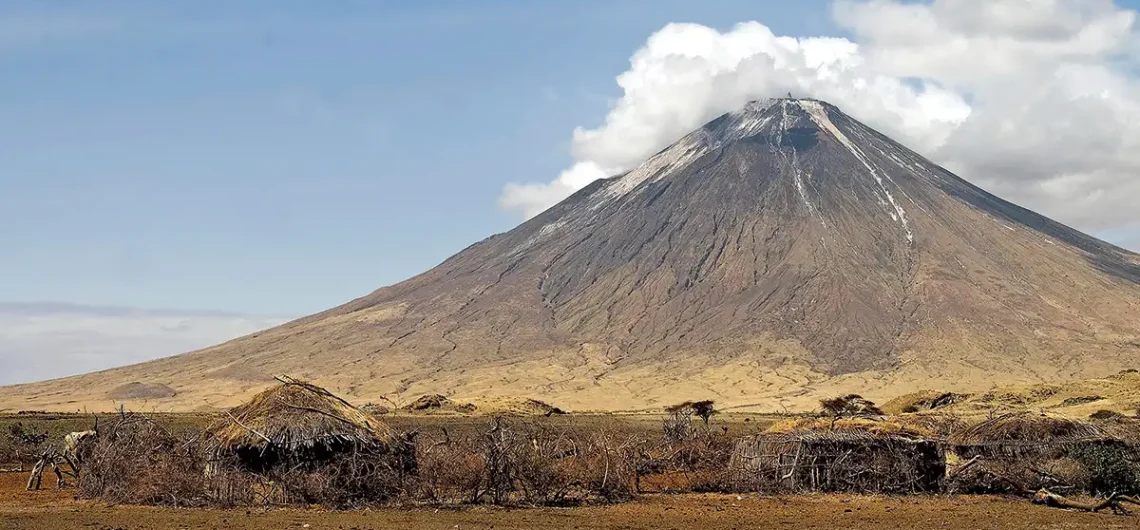
Ol Doinyo Lengai is situated in the eastern branch of the East African Rift System, positioned to the south of Lake Natron and near the approximately 400-meter-high Natron Escarpment of the Gregory Rift, which took shape around 1.2 million years ago.
Ol Doinyo Lengai, often referred to as the “Mountain of God” in the Maasai language, is a prominent volcano located in northern Tanzania, near the southern shores of Lake Natron. This majestic stratovolcano is part of the East African Rift system, which stretches from the Red Sea down through eastern Africa. Its distinctive cone shape and unique geological features make it a fascinating destination for adventurers, scientists, and nature enthusiasts alike.
Geographically, Ol Doinyo Lengai is situated in the eastern branch of the East African Rift, known as the Gregory Rift. This rift forms part of the tectonic boundary between the African Plate and the Somali Plate, where the Earth’s crust is slowly pulling apart. As a result, the region is characterized by volcanic activity, fault lines, and stunning landscapes.
The volcano itself rises dramatically from the surrounding plains, reaching an elevation of approximately 2,878 meters (9,442 feet) above sea level. Despite its relatively modest height compared to other famous peaks like Mount Kilimanjaro, Ol Doinyo Lengai holds immense geological significance due to its unique composition and eruptive behavior.
What sets Ol Doinyo Lengai apart from other volcanoes is its rare natrocarbonatite lava, which is the only known example of its kind in the world. Unlike typical basaltic lava, which is rich in silicate minerals, natrocarbonatite lava contains high levels of sodium and potassium carbonate minerals. This gives the lava a distinctive black color when cooled, earning Ol Doinyo Lengai the nickname “Mountain of God” among the local Maasai people.
The volcano is known for its frequent eruptions, which often produce spectacular lava flows that cascade down its slopes. These eruptions are relatively gentle compared to more explosive volcanoes, with the lava flowing slowly and steadily from fissures on the crater floor. Despite its frequent activity, Ol Doinyo Lengai poses little danger to surrounding communities due to its remote location and the relatively low viscosity of its lava.
In addition to its geological significance, Ol Doinyo Lengai holds cultural importance for the Maasai people, who consider the volcano to be a sacred site. According to Maasai tradition, the mountain is the home of Engai, the Maasai god, and serves as a spiritual beacon for their community.
Visitors to Ol Doinyo Lengai can embark on guided treks to explore its rugged terrain, witness its volcanic activity, and marvel at its breathtaking vistas. The journey to the summit is challenging but rewarding, offering unparalleled views of the surrounding landscape and the opportunity to witness the raw power of nature in action.
How to get to Ol Doinyo Lengai
To get to Ol Doinyo Lengai, the following transportation options are available:
- By Air: The nearest major airport to Ol Doinyo Lengai is Kilimanjaro International Airport (JRO) near Arusha. From there, you can arrange ground transportation to reach the mountain. Domestic flights may also be available to airstrips closer to the mountain, but these options are less common.
- By Road: The most common way to reach Ol Doinyo Lengai is by road. You can hire a private vehicle or join a guided tour from various cities and towns in Tanzania, such as Arusha, Moshi, or Karatu. The journey typically involves driving on both paved and unpaved roads, and it’s advisable to use a sturdy 4WD vehicle, especially for the final leg of the journey, which may require traversing rough terrain.
- Guided Tours: Many tour operators offer guided tours to Ol Doinyo Lengai as part of broader safari or trekking packages. These tours often include transportation, accommodation, meals, and the services of experienced guides and porters. Joining a guided tour can simplify the logistics of reaching the mountain and enhance the overall experience with local expertise and support.
- Local Transport: Once you arrive in the vicinity of Ol Doinyo Lengai, you may need to rely on local transport options, such as taxis, boda-bodas (motorcycle taxis), or hired vehicles, to access the starting point for trekking or climbing expeditions. Be sure to make arrangements in advance or seek assistance from local tour operators or accommodations.
Regardless of the mode of transportation you choose, it’s essential to plan ahead, consider the logistics of reaching the mountain, and prioritize safety and comfort during the journey.
Distance of Ol Doinyo Legai to various locations in Tanzania
Here are the approximate distances of Ol Doinyo Lengai from various locations in Tanzania:
- Arusha: Approximately 170 kilometers (105 miles) southeast of Ol Doinyo Lengai.
- Karatu: Approximately 70 kilometers (43 miles) northeast of Ol Doinyo Lengai.
- Ngorongoro: Approximately 90 kilometers (56 miles) northeast of Ol Doinyo Lengai.
- Serengeti: Approximately 200 kilometers (124 miles) northwest of Ol Doinyo Lengai.
- Lake Manyara: Approximately 150 kilometers (93 miles) east of Ol Doinyo Lengai.
- Tarangire: Approximately 180 kilometers (112 miles) southeast of Ol Doinyo Lengai.
- Kilimanjaro International Airport: Approximately 290 kilometers (180 miles) northeast of Ol Doinyo Lengai.
- Moshi: Approximately 220 kilometers (137 miles) northeast of Ol Doinyo Lengai.
- Dar es Salaam: Approximately 600 kilometers (373 miles) southeast of Ol Doinyo Lengai.
- Dodoma: Approximately 430 kilometers (267 miles) southwest of Ol Doinyo Lengai.
These distances are approximate and may vary depending on the specific starting and ending points within each location. It’s important to consider the road conditions and travel time when planning a journey to Ol Doinyo Lengai from these destinations.
Related articles:
- Where is Mount Kenya located?
- Where is Mount Meru located?
- Where is Rwenzori located?
- Where is Mount Kilimanjaro located
![]()


Comments