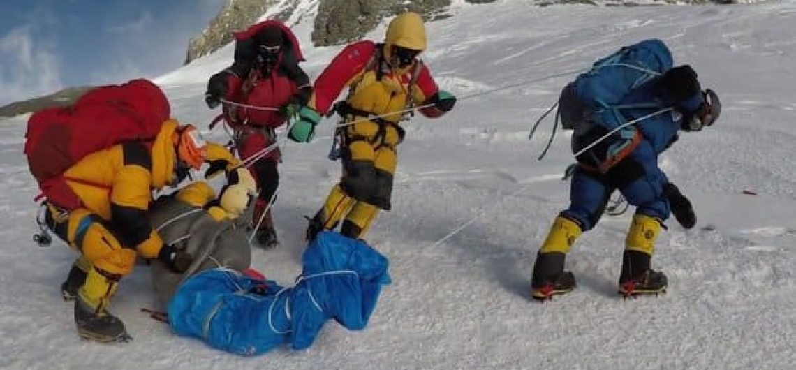
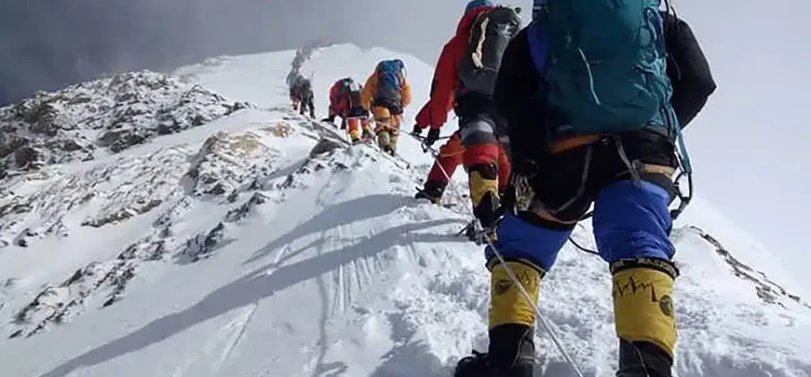
Recovering dead bodies on Everest is not as easy as it may sound. It is actually a long and costly process in itself. It is generally agreed that the optimal time to climb Mount Everest and other well-known mountains, such as Annapurna I, should be during the springtime. Every day, there are numerous attempts made to collect bodies from the summit of Mount Everest. One of the issues is that it is a hazardous line of employment. As can be seen from the picture in this illustration, the majority of the remains are discovered at elevations greater than eight thousand meters. Due to the fact that the amount of oxygen that is accessible at this point is approximately one third of what is available at sea level, this location is commonly referred to as the Death Zone. Your body does not even have the energy to digest food, let alone carry anywhere from 115 pounds (for a woman) to over 200 pounds (for a man) worth of physical dead weight down. This is because of the tremendous lack of oxygen that your body is experiencing. When you add to that the challenging terrain, the cold, and the possibility of an avalanche or rock fall, the risks become much more severe. Additionally, depending on how long the person has been up there, there is a possibility that they have frozen onto the mountain. This is a possibility that really exists. Additionally, there are a number of regions through which transportation with a deceased body is extremely challenging. Due to the fact that there are certain sections of the mountain that are nearly vertical, the body must be gently dropped by rope as the rescuers themselves attempt to make their way down. The fabled "ladder of death" can be found on the
Recovering dead bodies on Everest is not as easy as it may sound. It is actually a long and costly process in itself. It is generally agreed that the optimal time to climb Mount Everest and other well-known mountains, such as Annapurna I, should be during the springtime. Every day, there are numerous attempts made
Keep in mind that Mount Everest climbing cost estimates can vary widely depending on factors such as the route chosen, the level of support required, the duration of the expedition, and personal preferences for gear and services. It's essential to plan and budget carefully to ensure a safe and successful climb. The quick answer is about $45,000.00 but there are several choices to be made when climbing Mount Everest and each have different cost consequences: North or south side - climbing from Tibet's north side will cost slightly less. Guided or non-guided – A trip that focuses solely on logistics will be less expensive, but you will need to be able to provide for yourself on the mountain. A payment is made for the guide, which is typically more expensive for a Western guide than it is for a Nepali Sherpa. Guided outings are obviously included in this charge. Western or Nepalese operator – Because the cost of a western guide permit must be included, local companies will be more cost-effective. This is in addition to the compensation and trip expenses that the guide will be responsible for. Although it is arguable that Western corporations have higher overhead costs in their country, there are a significant number of individual guides who are also business owners and work from home. Bottled oxygen or not – It is a cost-effective option for those who do not use bottled oxygen, although the vast majority of people do use it. Around $465.00 is the price of a single bottle, and the majority of customers utilize seven bottles on a typical adventure. There is a broad range of pricing that commercial operators charge for climbing Mount Everest in the modern period; but, in general, a guided trip with bottled oxygen on the south side of the
Keep in mind that Mount Everest climbing cost estimates can vary widely depending on factors such as the route chosen, the level of support required, the duration of the expedition, and personal preferences for gear and services. It’s essential to plan and budget carefully to ensure a safe and successful climb. The quick answer is
There is no better location than Kala Patthar for those who are hoping to have a view of Mount Everest that is both more distinct and more expansive for themselves. Even though there are some challenges, the location provides you with the most breathtaking sight that you will never be able to get out of your thoughts! Therefore, when you go to the Everest region in the future, make sure that you include Kala Patthar on your list of things to do. Each year, thousands of people make the journey to Kalapatthar in order to witness the sunrise and sunset of Mount Everest. Kala Patthar, sometimes referred to as "Black Stone," is a well-known landmark that can be seen in the Khumbu region of Nepal with the same name. Furthermore, due to the breathtaking panoramic view that it offers from the peak, it is considered to be one of the most important attractions in the Everest region. Because it is just 10 meters into the air, Kala Patthar is not considered to be a mountain. On the other hand, it is the highest point that you are permitted to climb during Everest treks without obtaining a climbing permit. A. Patther, Kala It is located close to the Everest Base Camp and is situated at an elevation of 5,643 meters. In addition, the location offers a breathtaking panorama that encompasses the entire Mahanalgnur Himalayan Range in every direction. The three most notable mountains that can be seen from this vantage point are Everest, Changtse, and Nuptse. Nevertheless, because to the nature of the Everest massif, which is blocked by Mount Nuptse, the peak of Everest is unavailable for observation. Geographic Location On the southern crest of Mount Pulmori, which is part of the Mahalnagur Himalayan Range, is where you will find
There is no better location than Kala Patthar for those who are hoping to have a view of Mount Everest that is both more distinct and more expansive for themselves. Even though there are some challenges, the location provides you with the most breathtaking sight that you will never be able to get out of
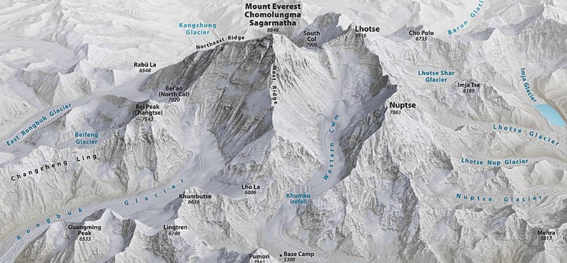
Do you know the location of Mount Everest? Our in-depth article will help you discover the answer and unravel the mysteries of the highest peak in the world. At the same time, we will give you a detailed map of where to find Everest and an interactive Google map that pinpoints exactly where the highest mountain in the world is. Mount Everest, which is the tallest peak in the world, can be found in the Himalayas, which are a mountain range that spans the borders of Nepal and Tibet. This legendary mountain, which reaches an astounding height of 8,848 meters (29,029 feet), presents mountaineers with a breathtaking challenge and captivates adventurers and nature fans alike with its compelling attractiveness. The awe-inspiring setting of Mount Everest is home to a remarkable combination of natural beauty, cultural history, and climbing accomplishments that are unmatched in the world. All people are well aware of Everest's splendour. To be more specific, the question that has to be asked is, "Where exactly is Mount Everest located?" A significant number of people are still unaware of the precise location of this breathtaking mountain panorama. To put it another way, Mount Everest can be found in the Between Nepal and Tibet is where you'll find Mount Everest. At a height of 8,848.86 meters (29,032 ft), it claims the title of being the tallest structure on the planet. The land was given the name Everest in honor of George Everest, who served as a Surveyor General in India during the 19th century. The position of Everest is a source of concern for those individuals who fantasize about experiencing the enchantment of Everest through outdoor activities such as trekking or climbing to the summit of the mountain. This essay was written with the intention of shedding light on the
Do you know the location of Mount Everest? Our in-depth article will help you discover the answer and unravel the mysteries of the highest peak in the world. At the same time, we will give you a detailed map of where to find Everest and an interactive Google map that pinpoints exactly where the highest
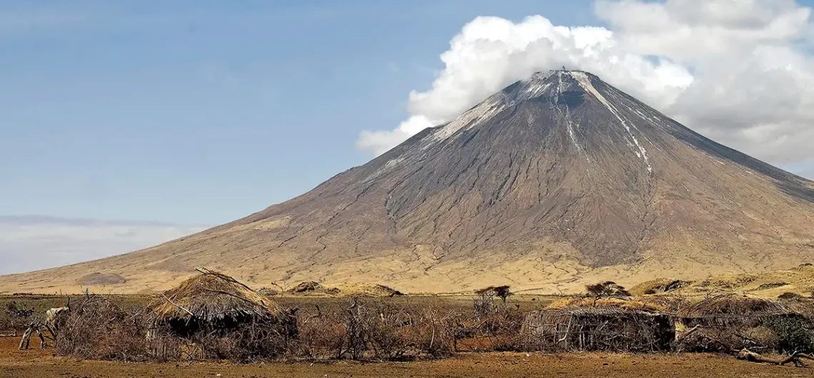
Ol Doinyo Lengai is situated in the eastern branch of the East African Rift System, positioned to the south of Lake Natron and near the approximately 400-meter-high Natron Escarpment of the Gregory Rift, which took shape around 1.2 million years ago. Ol Doinyo Lengai, often referred to as the "Mountain of God" in the Maasai language, is a prominent volcano located in northern Tanzania, near the southern shores of Lake Natron. This majestic stratovolcano is part of the East African Rift system, which stretches from the Red Sea down through eastern Africa. Its distinctive cone shape and unique geological features make it a fascinating destination for adventurers, scientists, and nature enthusiasts alike. Geographically, Ol Doinyo Lengai is situated in the eastern branch of the East African Rift, known as the Gregory Rift. This rift forms part of the tectonic boundary between the African Plate and the Somali Plate, where the Earth's crust is slowly pulling apart. As a result, the region is characterized by volcanic activity, fault lines, and stunning landscapes. The volcano itself rises dramatically from the surrounding plains, reaching an elevation of approximately 2,878 meters (9,442 feet) above sea level. Despite its relatively modest height compared to other famous peaks like Mount Kilimanjaro, Ol Doinyo Lengai holds immense geological significance due to its unique composition and eruptive behavior. What sets Ol Doinyo Lengai apart from other volcanoes is its rare natrocarbonatite lava, which is the only known example of its kind in the world. Unlike typical basaltic lava, which is rich in silicate minerals, natrocarbonatite lava contains high levels of sodium and potassium carbonate minerals. This gives the lava a distinctive black color when cooled, earning Ol Doinyo Lengai the nickname "Mountain of God" among the local Maasai people. The volcano is known for its frequent eruptions, which
Ol Doinyo Lengai is situated in the eastern branch of the East African Rift System, positioned to the south of Lake Natron and near the approximately 400-meter-high Natron Escarpment of the Gregory Rift, which took shape around 1.2 million years ago. Ol Doinyo Lengai, often referred to as the “Mountain of God” in the Maasai